
| Home | Sources Directory | News Releases | Calendar | Articles | | Contact | |
Biafra
|
|||||||||||||||||||||||||||||||||||||||||||||||||||


The Republic of Biafra was a secessionist state in south-eastern Nigeria. Biafra was inhabited mostly by the Igbo people and existed from 30 May 1967 to 15 January 1970. The secession was led by the Igbo due to economic, ethnic, cultural and religious tensions among the various peoples of Nigeria. The creation of the new country, named after the Bight of Biafra (the Atlantic bay to its south),[2] was among the complex causes for the Nigerian Civil War, also known as the Nigerian-Biafran War. Land of the Rising Sun was chosen for Biafra's national anthem.
Biafra was recognized by Gabon, Haiti, Côte d'Ivoire, Tanzania and Zambia. Other nations did not give official recognition, but provided assistance to Biafra. Israel, France, Portugal, Rhodesia, South Africa and the Vatican City provided support.[3] Biafra also received aid from non-state actors; Joint Church Aid, Holy Ghost Fathers of Ireland, Caritas International, MarkPress and U.S. Catholic Relief Services all gave support.[3]
Contents |
[edit] History
[edit] Secession
During 1960, Nigeria became independent of the United Kingdom.[4] Similar to the other new African states, the borders of the country were not drawn according to earlier territories. Hence, the northern desert region of the country contained semi-autonomous feudal Muslim states, while the southern population was predominantly Christian and Animist. Furthermore, Nigeria's oil, its primary source of income, was located in the south of the country.[4]
Following independence, Nigeria was divided primarily along ethnic lines with Hausa and Fulani in the north, Yoruba in the south-west, and Igbo in the south-east.[4] In January 1966, a group of primarily eastern Igbo led a military coup during which 30 political leaders including Nigeria's Prime Minister, Sir Abubakar Tafawa Balewa and the Northern premier, Sir Ahmadu Bello were killed.[5][6][7]
In July 1966 northern officers and army units staged a counter-coup. Muslim officers named a Christian from a small ethnic group (the Anga) in central Nigeria, Lieutenant Colonel Yakubu "Jack" Gowon, as the head of the Federal Military Government (FMG). The two coups deepened Nigeria's ethnic tensions. In September, 1966, approximately 30,000 Igbo were killed in the north, and some Northerners were killed in backlashes in eastern cities.[8]
Now, therefore, I, Lieutenant-Colonel Chukwuemeka Odumegwu Ojukwu, Military Governor of Eastern Nigeria, by virtue of the authority, and pursuant to the principles, recited above, do hereby solemnly proclaim that the territory and region known as and called Eastern Nigeria together with her continental shelf and territorial waters shall henceforth be an independent sovereign state of the name and title of "The Republic of Biafra".
In January 1967, the military leaders and senior police officials of each region met in Aburi, Ghana and agreed on a loose confederation of regions. The Northerners were at odds with the Aburi Accord; Obafemi Awolowo, the leader of the Western Region warned that if the Eastern Region seceded, the Western Region would also, which persuaded the northerners.[8]
After the federal and eastern governments failed to reconcile, on 26 May the Eastern region voted to secede from Nigeria. On 30 May, Chukwuemeka Odumegwu Ojukwu, the Eastern Region's military governor, announced the Republic of Biafra, citing the Easterners killed in the post-coup violence.[4][8] The large amount of oil in the region created conflict, as oil was a major component of the Nigerian economy.[10] The Eastern region was very ill equipped for war, out manned, and out gunned by the military of the remainder of Nigeria. Their advantages included fighting in their homeland, support of most Easterners, determination, and use of limited resources.[11] The British, Soviet Union, and U.S. support (especially militarily) of the Nigerian government played a major role in the outcome of the war.[12]
[edit] War

The FMG launched "police measures" to annex the Eastern Region in July 6, 1967. The FMG's initial efforts were unsuccessful; the Biafrans successfully launched their own offensive, taking land in the Mid-Western Region August 1967. By October 1967, the FMG had regained the land after intense fighting.[8][13]
In September 1968, the federal army planned what Gowon described as the "final offensive." Initially the final offensive was neutralized by Biafran troops. In the latter stages, a Southern FMG offensive managed to break through the fierce resistance.[8]
On 30 June 1969, the Nigerian government banned all Red Cross aid to Biafra; two weeks later it allowed medical supplies through the front line, but restricted food supplies.[13] Later in October 1969, Ojukwu appealed to United Nations to mediate a cease-fire. The federal government called for Biafra's surrender. In December, the FMG managed to cut Biafra in half, primarily by the efforts of 3 Marine Commando Division of the Nigerian Army, led by then Colonel Benjamin Adekunle popularly called 'The Black Scorpion' and later Olusegun Obasanjo. Ojukwu fled to the Ivory Coast, leaving his chief of staff, Philip Effiong, to act as the "officer administering the government". Effiong called for a cease-fire 12 January and submitted to the FMG.[8] More than one million people had died in battle or from starvation.[14][15]
[edit] Geography

Enclosed in Biafra's borders were over 29,848 square miles (77,310 km2) of land;[1] the land borders were shared with Nigeria to the north and Cameroon to the east. Its coast was on the Gulf of Guinea in the south.
The former country's southeast borders the Benue Hills and mountains that lead to Cameroon.
Two rivers flow from Biafra into the Gulf of Guinea: the Cross River and the Niger River.[16]
[edit] Climate
Biafra has a tropical climate with two distinct seasons, dry and rainy. From April to October the rainy season takes place, with heavy rain and high humidity. The heaviest rain occurs between June and July with up to 360 mm (14 in) of rain level. The temperature of the region on a clear day is 30 degrees Celsius (86 degrees Fahrenheit) high and 22 degrees Celsius (71.6 degrees Fahrenheit) low. The dry season starts in November and ends in April. The lowest rain level 16 mm (0.63 in) in February. The temperature at night reaches 20 –C (68 –F) and in the day has a peak temperature of 36 –C (96.8 –F).[17]
[edit] Language
The predominant language of Biafra was the Igbo language[18]. Along with Igbo there were a variety of other different languages, including Efik and Ibibio.
[edit] Economy

An early institution created by the Biafran government was the Bank of Biafra, accomplished under 'Decree No. 3 of 1967'.[19] The bank carried out all central banking functions including the administration of foreign exchange and the management of the public debt of the Republic.[19] The bank was administered by a governor and four directors; the first governor, per the signature on bank notes, was Sylvester U. Ugoh.[19] A second decree, 'Decree No.4 of 1967', modified the Banking Act of the Federal Republic of Nigeria for the Republic of Biafra.[19]
The bank was first located in Enugu, but due to the ongoing war, the bank was relocated several times.[19] Biafra attempted to finance the war through foreign exchange. After Nigeria announced their currency would no longer be legal tender (to make way for a new currency), this effort increased. After the announcement, tons of Nigerian bank notes were transported in an effort to acquire foreign exchange. The currency of Biafra had been the Nigerian pound, until the Bank of Biafra started printing out its own notes, the Biafran pound.[19] The new currency went public on 28 January 1968, and the Nigerian pound was not accepted as an exchange unit.[19] The first issue of the bank notes included only 5 shillings notes and 1 pound notes. The Bank of Nigeria exchanged only 30 pounds for an individual and 300 pounds for enterprises in the second half of 1968.[19]
In 1969 new notes were introduced: –10, –5, –1, 10/- and 5/-.[19]
It is estimated that a total of –115-140 million Biafran pounds were in circulation by the end of the conflict. This is a relatively small amount, however, as the Biafran population at the time was 14 million, meaning roughly –10 per person was in circulation.[19]
[edit] Military
At the beginning of the war Biafra had 3,000 troops, but at the end of the war the troops totaled 30,000.[20] There was no official support for the Biafran army by another nation throughout the war, although arms were clandestinely acquired. Because of the lack of official support, the Biafrans manufactured many of their weapons locally. A number of Europeans served in the Biafran cause; German born Rolf Steiner was a Lt. Colonel assigned to the 4th Commando Brigade and Welshman Taffy Williams served as a Major until the very end of the conflict.[21]
The Biafrans managed to set up a small yet effective air force. The BAF commanders were Chude Sokey and later Godwin Ezeilo, who had trained with the Royal Canadian Air Force.[22] Early inventory included two B-25 Mitchells, one B-26 Invader (piloted by Polish pilot Jan Zumbach, known also as John Brown), a converted DC-3 and one Dove. In 1968 the Swedish pilot Carl Gustaf von Rosen suggested the MiniCOIN project to General Ojukwu. By the spring of 1969, Biafra had built five MFI-9Bs in Gabon, calling them "Biafra Babies". They were coloured green, were able to carry six 68 mm anti-armour rockets and had simple sights. The six airplanes were flown by three Swedish pilots and three Biafran pilots. In September 1969, Biafra acquired four ex-Armee de l'Air North American T-6Gs, which were flown successfully to Biafra the following month, with another aircraft lost on the ferry flight. These aircraft flew missions until January 1970, flown by Portuguese ex-military pilots.[22]
[edit] Legacy

The international humanitarian organization Médecins Sans Frontières ("Doctors Without Borders") came out of the suffering in Biafra. During the crisis, French medical volunteers, in addition to Biafran health workers and hospitals, were subjected to attacks by the Nigerian army and witnessed civilians being murdered and starved by the blockading forces. French doctor Bernard Kouchner also witnessed these events, particularly the huge number of starving children, and, when he returned to France, he publicly criticised the Nigerian government and the Red Cross for their seemingly complicit behaviour. With the help of other French doctors, Kouchner put Biafra in the media spotlight and called for an international response to the situation. These doctors, led by Kouchner, concluded that a new aid organisation was needed that would ignore political/religious boundaries and prioritise the welfare of victims.[23]
In their book, Smallpox and its Eradication, Fenner and colleagues describe how vaccine supply shortages during the Biafra smallpox campaign led to the development of the focal vaccination technique, later adopted worldwide by the World Health Organization, which led to the early and cost effective interruption of smallpox transmission in west Africa and elsewhere.
On 29 May 2000, the Lagos Guardian newspaper reported that the now ex-president Olusegun Obasanjo commuted to retirement the dismissal of all military persons who fought for the breakaway state of Biafra during Nigeria's 1967'1970 civil war. In a national broadcast, he said the decision was based on the belief that "justice must at all times be tempered with mercy".[24]
Violence between Christians and Muslims (usually Igbo Christians and Hausa or Fulani Muslims) has been incessant since the end of the civil war in 1970.
In July 2006 the Center for World Indigenous Studies reported that government sanctioned killings were taking place in the southeastern city of Onitsha, because of a shoot-to-kill policy directed toward Biafran loyalists, particularly members of the Movement for the Actualization of the Sovereign State of Biafra (MASSOB).[25][26]
[edit] Movement to re-secede
The "Movement for the Actualization of the Sovereign State of Biafra" (MASSOB) advocates a separate country for the Igbo people of south-eastern Nigeria.[15] They accuse the state of marginalising the Igbo people. MASSOB says it is a peaceful group and advertises a 25-stage plan to achieve its goal peacefully.[27] there are two arms to the government, the Biafra Government in Exile and Biafra Shadow Government.[28] The Nigerian government accuses MASSOB of violence; MASSOB's leader, Ralph Uwazuruike, was arrested in 2005 and is being detained on treason charges; MASSOB is calling for his release. MASSOB is also championing the release of oil militant Mujahid Dokubo-Asari, who is facing similar charges.[15] In 2009, The MASSOB launched "the Biafran International Passport" in response to persistent demand by Biafrans in diaspora.[29]
[edit] Meaning of the word "Biafra" and location of Biafra
Little is known about the literal meaning of the word Biafra. It is not part of the Igbo language. It is unclear whether the origin of the word Biafra has any relationship to "Bia", the Igbo word for "Come". The word Biafra most likely derives from the subgroup Biafar or Biafada[30] of the Tenda ethnic group who reside primarily in Guinea-Bissau.[31] Manuel Álvares (1526'1583), a Portuguese Jesuit Educator, in his work "Ethiopia Minor and a geographical account of the Province of Sierra Leone", writes about the "Biafar heathen" in chapter 13 of the same book.[32] The word Biafar thus appears to have been a common word in the Portuguese language back in the 16th century.
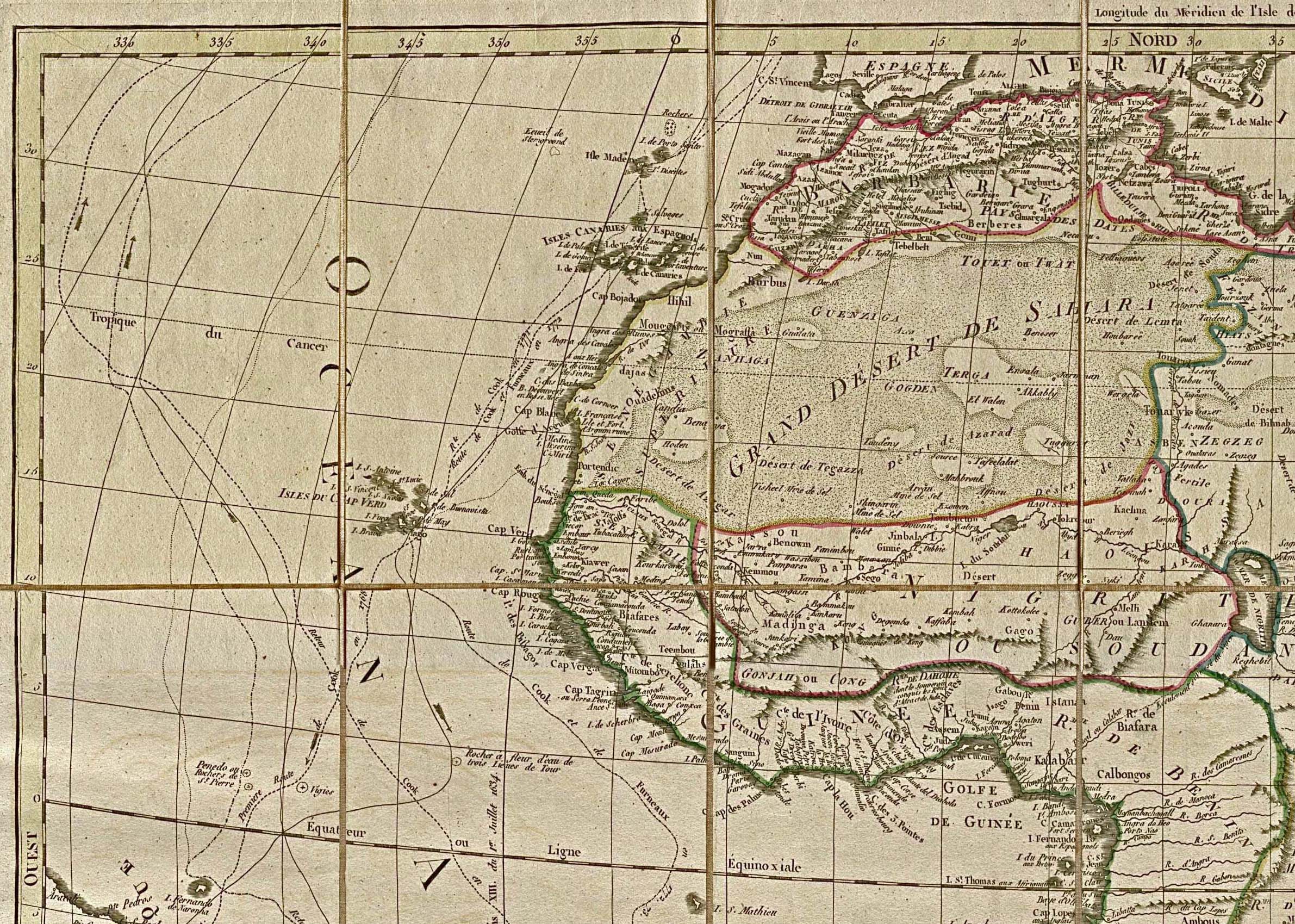
[edit] Historical maps of Biafra
Early modern maps of Africa from the 15th'19th centuries, drawn by European cartographers from accounts written by explorers and travellers, reveal some interesting information about Biafra:
- The original word used by the European travellers was not Biafra but Biafara[33][34], Biafar[35] and sometimes also Biafares[36].
- The exact original region of Biafra is not restricted to Eastern Nigeria alone. According to the maps, the European travelers used the word Biafara to describe the entire region east of River Niger going down to the Mount Cameroon region, thus including Cameroon and a large area around Gabon. The word Biafara also appears on maps from the 18th century in the area around Gambia.[37]
Maps indicating the word Biafara (sometimes also Biafares or Biafar) with corresponding year:
Maps from the 19th century indicating Biafra as the region around today's Cameroon:
[edit] See also
- Land of the Rising Sun (national anthem)
- List of A-26 Invader operators
- Manillas
- Nigerian Civil War
- Movement for the Actualization of the Sovereign State of Biafra
- Radio Northsea International
- Ambazonia
- Chimamanda Ngozi Adichie: Half of a Yellow Sun
- Rolf Steiner
- Taffy Williams
- Postage stamps and postal history of Biafra
[edit] References
- ^ a b Minahan, James (2002). Encyclopedia of the Stateless Nations: S-Z. Greenwood Publishing Group. p. 762. ISBN 0-313-32384-4. http://books.google.com/?id=K94wQ9MF2JsC&pg=PA762.
- ^ Room, Adrian (2006). Placenames of the World: Origins and Meanings of the Names for 6,600 Countries, Cities, Territories, Natural Features and Historic Sites. McFarland & Company. p. 58. ISBN 0786422483.
- ^ a b Nowa Omoigui. "Federal Nigerian Army Blunders of the Nigerian Civil War - Part 2". http://www.dawodu.com/omoigui25.htm. Retrieved 2008-08-15.
- ^ a b c d Barnaby Philips (2000-01-13). "Biafra: Thirty years on". The BBC. http://news.bbc.co.uk/2/hi/africa/596712.stm. Retrieved 2010-01-01.
- ^ Nowa Omoigui. "OPERATION 'AURE': The Northern Military Counter-Rebellion of July 1966". Nigeria/Africa Masterweb. http://www.africamasterweb.com/CounterCoup.html.
- ^ Willy Bozimo. "Festus Samuel Okotie Eboh (1912 - 1966)". Niger Delta Congress. http://www.nigerdeltacongress.com/farticles/festus_samuel_okotie_eboh.htm. Retrieved 2008-08-17.
- ^ "1966 Coup: The last of the plotters dies". OnlineNigeria.com. 2007-03-20. http://nm.onlinenigeria.com/templates/?a=9670&z=17.
- ^ a b c d e f "Biafran Secession: Nigeria 1967-1970". Armed Conflict Events Database. 2000-12-16. http://www.onwar.com/aced/data/bravo/biafra1967.htm.
- ^ "Ojukwu's Declaration of Biafra Speech". Citizens for Nigeria. http://www.citizensfornigeria.com/index.php?option=com_content&task=view&id=52&Itemid=63. Retrieved 2008-08-15.
- ^ "ICE Case Studies". American University. November 1997. http://www.american.edu/ted/ice/biafra.htm.
- ^ Nowa Omoigui (October 3, 2007). "Nigerian Civil War file". BBC. http://www.dawodu.com/omoigui24.htm. Retrieved 2007-10-27.
- ^ MAJOR ABUBAKAR .A. ATOFARATI (1992). "The Nigerian Civil War: Causes, Strategies, And Lessons Learnt". Global Security. http://www.globalsecurity.org/military/library/report/1992/AAA.htm. Retrieved 2005-04-27.
- ^ a b "On This Day (30 June)". BBC. 1969-06-30. http://news.bbc.co.uk/onthisday/hi/dates/stories/june/30/newsid_3733000/3733321.stm. Retrieved 2010-01-01.
- ^ James Brooke (1987-07-14). "Few Traces of the Civil War Linger in Biafra". New York Times. http://query.nytimes.com/gst/fullpage.html?res=9B0DEFD71E39F937A25754C0A961948260. Retrieved 2008-08-15.
- ^ a b c Senan Murray (2007-05-03). "Reopening Nigeria's civil war wounds". BBC. http://news.bbc.co.uk/2/hi/africa/6657259.stm. Retrieved 2008-08-15.
- ^ "Nigeria". Britannica. http://www.britannica.com/EBchecked/topic/414840/Nigeria#tab=active~checked%2Citems~checked&title=Nigeria%20--%20Britannica%20Online%20Encyclopedia. Retrieved 2008-08-17.
- ^ "Igbo insight guide to Enugu and Igboland's Culture and Language". http://www.igboguide.org/index.php?l=chapter2.
- ^ Ònyémà Nw�¡zùé. "INTRODUCTION TO THE IGBO LANGUAGE". http://ilc.igbonet.com. Retrieved 2008-08-18.
- ^ a b c d e f g h i j Symes, Peter (1997). "The Bank Notes of Biafra". International Bank Note Society Journal 36 (4). http://www.pjsymes.com.au/articles/biafra.htm. Retrieved 2008-08-17.
- ^ "Operation Biafra Babies". http://www.canit.se/~griffon/aviation/text/biafra.htm. Retrieved 2008-08-19.
- ^ "The Last Adventurer" by Steiner, Rolf (Boston:, Little, Brown 1978)
- ^ a b Air Enthusiast #65 September-October 1996 pp40-47 article by Vidal, Joao M. Texans in Biafra T-6Gs in use in the Nigerian Civil War
- ^ Bortolotti, Dan (2004). Hope in Hell: Inside the World of Doctors Without Borders, Firefly Books. ISBN 1-55297-865-6.
- ^ [1]
- ^ Emerging Genocide in Nigeria
- ^ Chronicles of brutality in Nigeria 2000-2006
- ^ Estelle Shirbon (2006-07-12). "Dream of free Biafra revives in southeast Nigeria". Reuters. http://www.boston.com/news/world/africa/articles/2006/07/12/dream_of_free_biafra_revives_in_southeast_nigeria/.
- ^ http://biafra.cwis.org/news20090413.php
- ^ http://www.vanguardngr.com/2009/07/01/massob-launches-biafran-intl-passport-to-celebrate-10th-anniversary/comment-page-2/
- ^ "Biafada: A language of Guinea-Bissau". http://www.ethnologue.com/show_language.asp?code=bif.
- ^ "The Joshua Project: Biafada, Biafar of Guinea-Bissau". http://www.joshuaproject.net/peopctry.php?rog3=PU&rop3=101403.
- ^ "Manuel Álvares, Chapter 13: The Biafar Heathen". http://digicoll.library.wisc.edu/cgi-bin/AfricaFocus/AfricaFocus-idx?type=article&did=AFRICAFOCUS.ALVARES01.I0019&id=AfricaFocus.Alvares01&isize=M.
- ^ "Map of Africa from 1669". USA: Afriterra Foundation, The Cartographic Free Library, http://www.afriterra.org/. http://catalog.afriterra.org/viewMap.cmd?number=785. Retrieved 14 March 2010.
- ^ "Map of Africa from 1669". USA: Afriterra Foundation, The Cartographic Free Library. http://catalog.afriterra.org/zoomMap.cmd?number=785. Retrieved 14 March 2010.
- ^ "Map of West Africa from 1729". USA: University of Florida, George A. Smathers Libraries. http://www.uflib.ufl.edu/maps/ALW1663L.JPG. Retrieved 14 March 2010.
- ^ "Map of North-West Africa, 1829". USA: University of Texas Libraries. http://www.lib.utexas.edu/maps/historical/africa_nw_1829.jpg. Retrieved 14 March 2010.
- ^ "Map of Africa from 1707". Minneapolis, Minnesota, USA: James Ford Bell Library. 9 October 2001. http://bell.lib.umn.edu/historical/H_af_m1.html. Retrieved 14 March 2010.
[edit] External links
| Wikimedia Commons has media related to: Biafra |
- My Biafran Eyes - Writer Okey Ndibe's memoir of the Biafran War in Guernica
- These Women Are Brave - A project on Igbo women's experiences during the Biafran war.
- Remember Biafra Page [2] - A brief history on the Republic and conflict
|
|||||||||||||||||
|
SOURCES.COM is an online portal and directory for journalists, news media, researchers and anyone seeking experts, spokespersons, and reliable information resources. Use SOURCES.COM to find experts, media contacts, news releases, background information, scientists, officials, speakers, newsmakers, spokespeople, talk show guests, story ideas, research studies, databases, universities, associations and NGOs, businesses, government spokespeople. Indexing and search applications by Ulli Diemer and Chris DeFreitas.
For information about being included in SOURCES as a expert or spokesperson see the FAQ . For partnerships, content and applications, and domain name opportunities contact us.